Integrating Knowledge to Assess Coastal Vulnerability to Sea-Level Rise In El- Mex Bay, Egypt: The Application of the DIVA Tool 
2. Physical Oceanography Laboratory, National Institute of Oceanography & Fisheries (NIOF), Alexandria, Egypt
 Author
  Correspondence author
International Journal of Marine Science, 2015, Vol. 5, No. 46 doi: 10.5376/ijms.2015.05.0046
Received: 27 Apr., 2015 Accepted: 31 May, 2015 Published: 30 Jul., 2015
El-Raey M., Nasr S and Hendy Dina M., 2015, Integrating Knowledge to Assess Coastal Vulnerability to Sea-Level Rise In El- Mex Bay, Egypt: The Application of the DIVA Tool, International Journal of Marine Science, 5(46): 1-7 (doi: 10.5376/ijms.2015.05.0046)
1 Introduction
The vulnerability of the Mediterranean coastal zone to sea-level rise has already been investigated (Jeftic et al., 1992), whilst Nicholls and Hoozemans (1996), using the Global Vulnerability Analysis (GVA), have shown that the southern part of the Mediterranean coast is more vulnerable than its northern part. The coastal zone of Egypt in particular, is most vulnerable to the impacts of climate change, not only because of the impact of sea-level rise, but also because of the impacts on water, agriculture and tourism resources and human settlements. A framework of an action plan has recently been advanced by Egyptian authorities (El Raey et al., 2005). An integrated coastal zone management plan for the coastal zone of Alexandria was carried out by (Nasr et al., 1997). Therefore, the impact of sea-level rise on lowland coasts is most likely associated with two different mechanisms: (i) inundation that is related mostly to sub-aerial topography and to the rate of sea-level rise; and (ii) erosion, which is controlled by shore zone morphology and nearshore hydrodynamics. Especially for long-term coastal evolution, the rate of sea-level change has been recognized as one of the most important driving factors among marine processes (Sánchez-Arcilla et al., 2000).
The overall objective of this work is to assess quantitatively the vulnerability to sea-level rise of El- Mex Bay, located west of Alexandria and one of most important fishery ground as well as recreation area. The specific objectives of this paper are: (1) to determine areas at risk of flooding and erosion, (2) to assess the most vulnerable socioeconomic sectors at risk, and (3) to identify the most appropriate response options for the areas at risk. The study describes the development of the DIVA-GIS (Dynamic and Interactive Vulnerability Assessment) tool, a user friendly tool for assessing coastal vulnerability in El- Mex Bay.
2 Description of the study area
El-Mex Bay is located west of Alexandria City bordering an industrial zone, one of the most densely populated cities with 6 million people (Figure 1). This bay extends for about 7 km between longitude 29° 45′ and 29° 54′ E and latitude 31° 07′ and 31° 15′ N, from Agami headland (west) to the Western Harbor (east), occupies an area of 19.4 km2, with a mean depth of 10 m and a water volume of 190.3x10⁶ m3.
.png) Figure 1 The basic map of the study region illustrating boundaries, main companies, water resources, drains and canals |
The bay receives about 2.547 x 10⁹ m3y-1 of agricultural wastes mixed with water effluents (surplus water) from a neighboring sewage-polluted lake (Lake Maryut) with a rate of 262.8 x 10⁶ m3y-1 via El-Umoum drain (Halim et al., 1995). In addition, the bay receives 13 x 106m3y-1 of industrial discharge, as well as water from the Western Harbor amounting to1.13x106 m3y-1. The residence time of El- Mex bay water was found to be around 28 days (Halim et al., 1995). Accordingly, this bay is considered as an estuarine zone of the huge agricultural El- Umoum drain.
2.1 Morphodynamic changes
El-Umoum drain is a large agricultural drain that opens directly into the Mediterranean Sea at El-Mex Bay, west of Alexandria (Figure 2). Its average flow rate is ~6.6 million m3/day (2547.7x106 m3/year) all year round (El-Rayis and El-Sabrouti, 1997). The drain water is slightly brackish with salinity of about S‰ 3.3, (Hossam and Petras, 1998), and is composed mainly of agricultural drainage water drained from cultivated fields in the northwest part of the Nile Delta (Bohaira and a part of the Alexandria provinces).
.png)
2.2 Socio-economic background
The population of El- Amirya District, according to census 2006 about 835.209 people, and occupies El- Amirya ranked second in terms of population of the total number districts of the Governate of Alexandria. There are two parts in El- Amirya district; Department of El- Dekhela which has five heachat are (El- Dekhela, El- Mex, East El- Bitash, West El- Bitash and El- Agami) and Department of El- Amirya (Ministry of Housing, utilities and Urban Development, 2010) (Table 1). The population of El- Mex according to census 2006 is about 110,239 people with 20.4 % from the total percent (El-Amirya District). The distribution of residential area in EL- Mex and El- Dekhela sector is illustrated in Figure (3). Area, population and percent of them from total in El- Amirya district (Ministry of housing, utilities and urban development, 2010) shown in (Table 2 and Figure 4).
.png) Table 1 Distribution of Land use in El- Amirya district (Ministry of housing, utilities and urban development, 2010) |
.png)
.png)
|
Table 2 Area, population and percent of them from total in El- Amirya district (Ministry of housing, utilities and urban development, 20109) |
3 Methodology
The methodology used to assess the vulnerability to sea-level rise and their consequences of the area was based on assumption of scenarios for sea-level rise.
The scale 1:25000 was found to be the most appropriate one for this study, as with its regional coverage, all necessary map features were obviously clear and interpreted. A vector depending software was used for the purpose of digitizing the map features. AutoCAD software was used for this purpose for its high digitization capabilities, also, using ARC-GIS 9.3 in finalizing and visualizing data. For the analysis of wind, current and wave, it is necessary to use wind and current rose program like Wind Rose Plots for Meteorological Data (WRPLOT View), Lakes Environmental software version 7.
The DIVA method is a method for building modular integrated computer models by distributed partners. It was developed to address the aforementioned challenge of supporting the process of integrating knowledge. DIVA has two versions 5.2 (September, 2005) and 7.5 (January, 2012), in this thesis the last version used (Figure 5).
.png)
4 Results and discussion
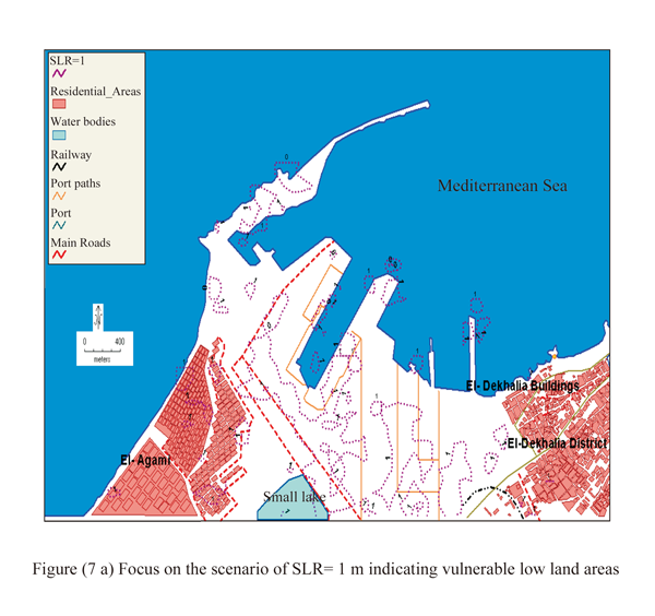
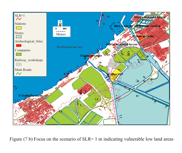
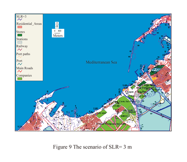
The sea-level rise is obtained from DEM (Digital Elevation Model, Mosaic_SRTM Dem, _EGYPT, 2000) (Figure 6). A number of scenarios of sea-level rise of El- Mex Bay are assumed 1, 2, 3 m as shown in (Figures 7, 7a, 7b, 8 and 9). The residential, land-use, and industrial areas at risk for each scenario level are identified.
.png)
.png)
.png)
Analysis of results indicates that for SLR= 1 m, El- Agami will be lost which contain 5981 inhabitants. Railway, port and port paths will be also under risk (Figure 7). Also, El- Mex station and a number of companies (AMOC, Petrogas Company, Alexandria Company for petroleum, Company Exon Mobil for oil, Misr petroleum, Cooperation of the Petroleum Company and Plant Oils Company) will be lost due to inundation. Also, number of stores (Alexandria Company for refrigerator cooling) and some Archeological Sites like El qatane castle and El Matras castle (Figure 7a and b).
While, for SLR= 2 m, in addition to the areas lost in the previous scenario. Many residential areas will be lost like Wadi El-Qamar, El-Wardean, Nag El-Arab, and El-Matras. Over 299439 inhabitants will have to be moved (Figure 8).
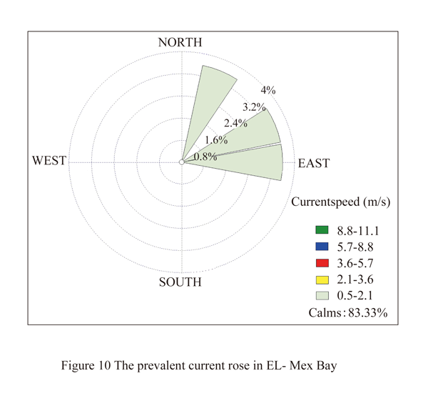
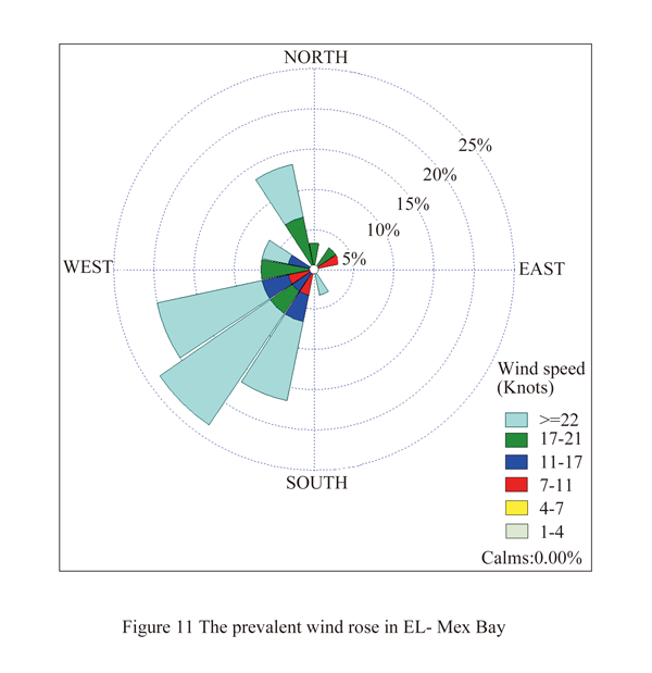
The predominant current directions were directed north-eastward under the influence of the north-westerly wind and sometimes directed south-eastward when the wind has a south-westerly component in December 2012 and January 2012. The maximum current speed observed in December 2012 was 86.21 cm/s (Figure 10).
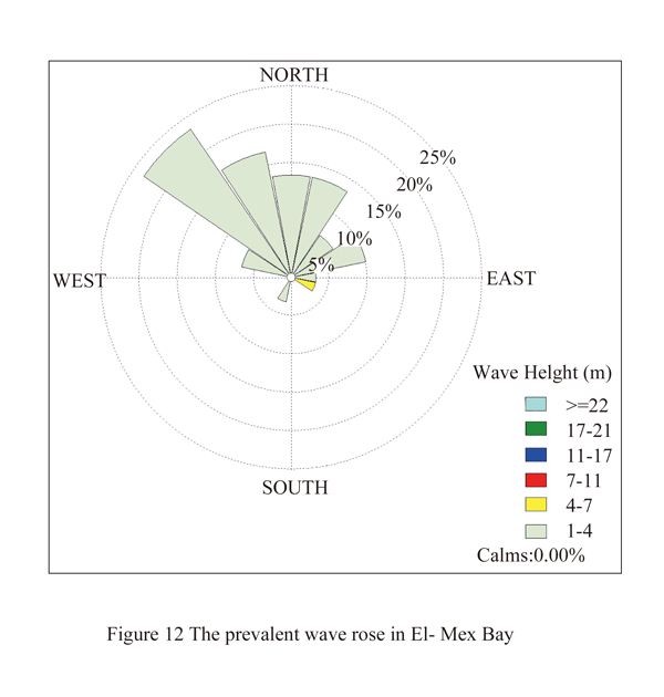
The prevailing wind and wave direction over El- Mex Bay was from NW during most of the year except in December and January 2012 where it was SW. The highest values of wind speed occurred during the winter storms and the highest speed was recorded in January 2013, 29.8 knots (Figures 11, 12).
5 Interpretations
The results show that sea-level rise poses a significant risk to El- Mex Bay. With such a large and growingpopulation in the coastal zone and a low ability to adapt because of poverty and adaptive capacity, the resilience becomes very low. Table (3) shows interpretation of results of the risks due to inundation to each scenario.
Analysis of results indicate that for SLR of 1m, an area of about 22982.4 Km2 (21.3 %) of study area will be lost due to inundation. Over 5981 inhabitants (0.99%) will have to move away and many industries occupying 161.28 Km2 (21.3%) and archeological sites and tombs occupying 20.58 Km2 (0.4%) will be lost.
For SLR of 2m, an area of about 29520.96 Km2 (59.9 %) of study area will be lost due to inundation. Over 299439 inhabitants (71.89%) will have to move away and many industries occupying 197.82 Km2 (21.3%) and archeological sites and tombs 59.64 Km2 occupying (11.1%) will be lost.
For SLR of 3 m, an area of about 2212560 Km2 of study area will be lost due to inundation. Over 13303.9 inhabitants will have to move away and many industries occupy 51.9 and many archeological sites and tombs 70.56 Km2 will be lost.
In spite of winter storms that attack El- Mex Bay, the recession rate of EL- Mex Bay is low due to the compartmented nature of the shoreline and the nature of shoals and very coarse sand of beach at El- Mex Bay. However, the existing erosion may be due in part to the recent reduction of the sediment supply, formally provided by El- Umoum Drain.
6 Response strategies and adaptation
In spite of the large uncertainty regarding projected climate scenarios and empirical calculations, and given the potential impacts of SLR on various socio-economic sectors of El- Mex Bay, an anticipatory adaptation strategy must be developed. This should be based on a pro-active approach and ‘no regrets’ policy. However, it is clear that the vulnerability of El- Mex to SLR will be mainly determined by the nature of ongoing development and the way the authorities manage its environment. In fact, coastal adaptation processes to climate change interact with existing management practices and can be considered multi-stage and iterative processes (Klein et al., 1999). Therefore, an integrated coastal zone management (ICZM) plan is the most appropriate and necessary tool for long-term sustainable development, which could tackle current and future vulnerabilities of the coastal area. This plan should actively involve the local communities, and include building regulations, urban growth planning, building institutional capacity and raising awareness (Snoussi and Tabet Aoul, 2000). Such plan should deal with both SLR and other impacts of climate change and/or human activities, and ensure that coastal development does not increase the vulnerability of the region. It requires the availability of a geographic database with relevant, detailed and accurate information, a monitoring system and a decision support system (El Raey et al., 1999).
Short-term adaptation measures are also necessary. The most suitable range or mixes of options that are recommended for the study area include:
1) Beach nourishment, including building artificial structures as storm buffers and beach sand reservoirs. This option would be beneficial even in the absence of SLR;
2) Hard structures should be designed, as much as possible, to avoid adverse environmental impacts. Groins could be used with beach nourishment to trap sand in the bay. Breakwaters could reduce the energy of the north-western waves reaching the shoreline. Building of seawalls is a high cost option; it would be used only for settlements and industrial areas of high value and at direct risk of inundation.
7 Conclusion
Application of DIVA-GIS methodology to assess the physical vulnerability El- Mex coastal zone has allowed the quantification of areas at risk of coastal inundation and erosion due to accelerated sea-level rise. Even if accurate data on ‘relative’ SLR, as well as knowledge of the hydrodynamics of the bay were lacking, results give a preliminary estimation of the areas at risk.
The DIVA-GIS map scenarios constituted a valuable tool for visualized SLR scenarios. Scenarios map allowed the authors to determine that the most vulnerable zones to inundation are many industries, research stations, and the port, the urban area, the coastal infrastructures, and the railway. Urban settlements including industrial areas would be the most affected economic assets, while residential lands are relatively preserved due to their high altitude. The bay of El- Mex seems vulnerable to impacts of SLR. However, the high population density and vital economic sectors make the potential socioeconomic impacts of SLR on El- Mex Bay of particular concern.
It is recommended that adaptation measures should include ‘soft’ maintenance such as beach nourishment and restoration; and some ‘hard’ structures to reduce the wave energy and to protect the industrial and urbanized areas. More important are raising awareness and building regulations, in the context of an ICZM plan, for long-term development. These results should be completed by a detailed vulnerability assessment, including physical impacts on freshwater and biological resources, socio-economic impacts, and evaluation of adaptation options, using the combination of cost-benefit analysis with multi-criteria analysis.
References
El Raey M., Nasr S., Frihy O., Fouda Y., El- Hattab M., El- Badawy O., Shalaby A., and Mohammed W., 2005, Sustainable Management of Scarce Resources In the Coastal Zone, D06.2: Case Study Report (Abu Qir Bay, Egypt), 125 pp.
El- Rayis, O. A. and Abdallah, M. A., (2006). Contribution of Nutrients and some Trace Metals from a Huge Egyptian Drain to the SE-Mediterranean Sea, west of Alexandria, Mediterranean Marine Science, (7/1): 79-86
El- Rayis, O. A. and El- Sabrouti, M. A. 1997. Lake Maryut: pollution problems and proposals for restoration. Fresenius Environmental Bulletin 6: 598- 604
El Raey, M., Dewidar, Kh., and El Hattab, M., 1999. Adaptation to the impacts of sea level rise in Egypt. Climate Research 12, 117-128
http://dx.doi.org/10.3354/cr012117
Halim, Y., Morcos, S. A., Rizkalia, S., and El- Sayed, M. Kh., 1995. The impact of the Nile and Suez Canal on the living marine resources of the Egyptian Mediterranean waters (1958- 1986), FAO Fisheries Technical Paper, Effects of riverine inputs on coastal ecosystems and fisheries resources, 19-57
Hossam, A. H. and Petras, J. L., 1998. Modeling of a drainage system contaminated by wastewater. 24th WEDC Conference Sanitation and Water for All, Islamabad, Pakistan. pp. 161-164
Jeftic L., Milliman J., and Sestini G. (Eds.), 1992. Climatic Change and the Mediterranean. UNEP. 645 pp.
Nasr, S. M., El Raey, M. and Ahmed, M. H., 1997. Integrated coastal zone management for Alexandria, Egypt. In: Proceedings of the Third International Conference on the Mediterranean Coastal Environment, MEDCOAST 97, Ozhan, e. Ed., Qawra, Malta: p. 15
Nicholls R.J., and Hoozemans F.M.J., 1996, The Mediterranean: vulnerability to coastal implications of climate change. Ocean and Coastal Management 31, 105132
Ministry of housing, utilities and urban development, 2010. Prepare a comprehensive overview of housing issues and climate change added to the housing market (the city of Alexandria), under the auspices of Urban Planning Authority, United Nations Development Programme, Canada Mortgage and Housing Corporation, and Canadian International Development Agency.
Klein, R.J.T., Nicholls, R.J., and Mimura, N., 1999. Coastal Adaptation to Climate Change: Can the IPCC Technical Guidelines be Applied?. Mitigation and Adaptation strategies for Global Change, vol. 4. Kluwer, Dordrecht, The Netherlands, pp. 239-252
Sánchez-Arcilla, D., Suanez, S., and Provansal, M., 2000. Morphosedimentary behavior of the deltaic fringe in comparison to the relative sea-level rise on the Rhone delta. Quaternary Science Reviews, 15: 811-818
Snoussi, M., and Tabet Aoul, E.H., 2000. Integrated coastal zone management programme, northwest African region case. Ocean & Coastal Management, 43, 1033-1045
http://dx.doi.org/10.1016/S0964-5691(00)00071-5


. PDF(1260KB)
. HTML
Associated material
. Readers' comments
Other articles by authors
. El-Raey M.
. Nasr S.
. Hendy Dina M.
Related articles
. Climate change
. Integrated Coastal Zone Management (ICZM)
. Sustainable development
. Sea-level rise (SLR)
. Coastal vulnerability
Tools
. Email to a friend
. Post a comment