2. Department of Life Science and Bioinformatics and School of Life Sciences Assam University, Silchar- 788011, Assam, India
 Author
  Correspondence author
International Journal of Marine Science, 2015, Vol. 5, No. 48 doi: 10.5376/ijms.2015.05.0048
Received: 18 Jun., 2015 Accepted: 19 Jul., 2015 Published: 17 Aug., 2015
Das B.K and Kar D., 2015, Habitat Inventory Parameters and Drainage Analysis of River Siang in Arunachal Pradesh, International Journal of Marine Science, 5(48): 1-7 (doi: 10.5376/ijms.2015.05.0048)
River Siang is the one of the major rivers of Arunachal Pradesh and also an important influent tributary leading to the mighty River Brahmaputra. River Siang is Hill-Stream 1st order river; has colluvial valley segment and pool-riffle type of reach. This reach type is most commonly associated with small to mid-size streams and is a quite prevalent type of reach in the rheophilic zones. Pools and riffles alternating with cascades are generally found to dominate the micro-habitat type with frequent occurrence of trench pools. The substrate type has been found to be dominated by bedrocks, boulders, gravels and cobbles.
An analysis of the drainage network of a part of River Siang was undertaken to reveal the role of drainage water activity of the area. A number of fluvial geomorphic dissimilarities have been identified in the area. A prominent annular pattern is observed in the central part of the area. The total length of River Siang in Arunachal Pradesh is 293.9 km. This study revealed that the development of topography and drainage system of the study area have been influenced by active sub-surface geological structures.
1 Introduction
The main threats to freshwater fishes are due to habitat alteration, pollution, overexploitations and introduction of non-native species causing their global decline (Nguyen and De Silva, 2006). The conservation of freshwater habitats and the associated fauna has increasingly become a priority (Allan and Flecker, 1993; Richter et al., 1997). It is imperative to inventories the freshwater fishes at both local and regional levels; so that, the conservation status of the species could be ascertained and the nature and magnitude of threats identified (Pethiyagoda, 1994; Dudgeon, 2000). This diversity is being eroded each day mainly because of unending anthropogenic stress. It is not only the wealth of India and the world but it also has serious implications on fishery domain.
Rivers are highly sensitive to any change, tectonic climatic conditions of an area. As such, they are the most powerful indicator of these activities. The tectonic deformation causes the changes in channel slope, which, in turn, is responsible for variation in channel morphology, fluvial process and hydrological characteristics of a river system (Jain and Sinha, 2003). River Siang is spreading into the different tectonic and litho-logic domain. The river system also provides a unique opportunity to study the evolution of fluvial landscape (Talukdar, 2011).
2 Study site
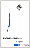
The River Siang, is largest river of Brahmaputra river system, originates from Chema Yungdung Glacier near Kubi at 5150 m in Tibet (Figure 1). In Tibet it is popularly known as Tsang-Po, flows in West–East direction. After traversing a distance of about 1625 km river in Tibet and then it takes a turn in south direction, enters the territory of India near Tuting in the Upper Siang district of Arunachal Pradesh and flows through North-South direction in East Siang district towards Assam and finally it merges with Lohit and Dibang in Assam and it becomes the mighty River Brahmaputra (Das et. al., 2014 a; Das and Kar 2015).
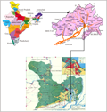 Figure 1 Map of (A) India indicating Arunachal Pradesh, (B) Arunachal Pradesh indicating to East Siang District, (C) In East Siang district highlighting River Siang (Study Area) of Arunachal Pradesh |
3 Materials and Methods
Habitat inventory parameters were recorded in a standard format (NBFGR, 2000) from each study spot in the field itself. The geographical co-ordinates and altitude above mean sea level (m.s.l.) of study spots were recorded with the help of Garmin made GPS-60. Habitat features were quantified using transects within each stream reach. Variables measured at each point of transect were water depth and width of the river and current speed. In each study point of the stream, in a reach measuring 100 m in length (the longitudinal path following the fastest cross sectional water velocities) micro-habitats were identified, classified, (such as, Fall, Cascade, Riffles, Pools and Run, sheet), and various measurements taken (Armantrout, 1990; Kar 2007, 2013; Arunachalam,1999; Das and Kar, 2011).
The study area covers a major part of East Siang District of Arunachal Pradesh latitudes 28002/43.16// - 28010/28.87//N and longitudes 95013/05.30//- 95021/39.00// E and altitude 501- 1681 Ft.; which is included in the
Survey of India (SoI) topographic map nos. 82 O/11, 82O/12, 82 O/15, 82 O/16, 82P/9, 82P/10, 82P/11, 82P/12, 82P/13, 82P/14, 82P/15, 82P/16, 83M/5 and 83M/9 on 1:50,000 scale. The satellite Images LISS III were collected from the NRSC Hyderabad, India, Bhuvan and also from USGC. The present study is confined to both the plain and hill areas because drainage anomalies in the plains and hills indicate the influence of subsurface structures, which are active in nature (Saha et al., 2006; Saders and Tabuchi, 2000; Das et al., 2014 b).
4 Results and Discussion
River Siang, a hill-Stream of 1st order river; had colluvial (landslide from adjacent hill slopes delivering sediments and organic matter) valley segment and pool-riffle type of reach. This reach type was most commonly associated with small to mid-size streams and was a quite prevalent type of reach in the rheophilic zones. On the other hand, runs were generally laminar flow of water with sandy substratum. Pools, riffles and runs were generally found to dominate the micro-habitat type with frequent occurrence of trench pools. River Siang was said to be more entrenched based on V-shaped valley segment. The substrate type had been found to be dominated by boulders, gravels and cobbles with frequently-occurring quite large number of boulders and some bed rocks. This kind of habitat with concomitant physico-chemical characteristics of water was said to be a suitable feeding and breeding ground for Tor spp. and Neolissochilus spp.
The substrate of River Siang was dominated by boulders. The level of embeddedness was high for large boulders and low for small cobbles. About 57% of the sample site was covered by boulders, 18% by thick layer of cobble, sand and gravel 24% each and remaining by silt and clay particles 1% showed in Figure 2. The boulders and cobbles provided hiding and spawning place for many hill stream fish species.
The riparian type was generally mesoriparian while the riparian vegetation type is generally deciduous trees with some amount of shrubs and grasses. Different types of fish covers had been recorded in River Siang ranging from undercut bedrock to bottom-free big boulders and pools. Riparian land use pattern mainly involves human habitation and some amount of agriculture through ‘Jhum’ cultivation. Field observations revealed differences in habitat preferences among the fishes of different size groups. Nevertheless, the fishes in River Siang seem to prefer deep pools as one of their favourable habitats in view of depth, providing strong cover to them. However, they also make use of covers like bottom-free big boulders, undercut banks, etc. (Table 1). Riparian vegetation did not seem to provide much cover to these fishes.
Habitat Inventory of River Siang, in the province of Arunachal Pradesh, was studied in six sectors, two sectors each in the upstream, mid-stream and downstream stretches. The study revealed differences in valley segment among the different sectors of the River Siang. In the plain region of the river, the valley segment was alluvial; while, in the true hill stream stretches i.e. in the upstream regions of the river, the valley segment was colluvial. The latter makes the habitat colonisable for the rheophilic fishes, most of which had developed adhesive apparatus on the ventral surface of the body in order to withstand the fast torrent of the river. Further, colluvial valley segment provides a diversity of micro-habitats while the alluvial valley segment generally showed only regime type of reach. Moreover, the River Siang was generally wider where there was alluvial valley segment. The fish covers in the studied river had been found to be mostly turbulence and depth. In some regions, fish cover was dominated by overhanging vegetation. The substrate type in the hilly portion of the River Siang was found to be dominated by gravels, cobbles, boulders and bedrocks; while, in the plain portion of the river, the substrate type mostly consists of fines. It was mesoriparian in the River Siang. But the riparian vegetations vary from shrubs to trees in the different regions of the river. Signs of erosion had been predominantly visible in all the studied segments of the River Siang.
In general, it had been found that, species diversity increases from upstream to downstream regions in the streams. According to McConnell (1988), this was due to the fact that, habitat diversity also increases along the stream gradient; but, may not be in the same direction and fashion, as species diversity. In addition, detritus and plankton richness also seem to increase downstream which may lead to greater diversity in the higher trophic levels. Certain studies on African stream fish communities (Toham and Teugels, 1997) revealed the occurrence of distinct pattern (s) in the longitudinal zonation of species with a sequential shift in species compositions and also an increase in species diversity along the stream gradient. Further, spatial segregation of fishes was said to be influenced by environmental and physical characteristics of the stream like width, depth, current velocity and substrate type (Toham and Tuegels, 1998); as well as, certain biotic characteristics like canopy cover and the occurrence of the in-stream detritus.
However, riffle and pool communities were linked by a continuous gradient; at a very local scale and species may use both these habitats at different parts of their life cycles, as well as, during different seasons (Schlosser, 1982). Nevertheless, some of the juvenile fish may prefer riffles to pool habitats; as they provide the required kind of food and flow patterns necessary at a particular stage of their growth; whereas, the same species may prefer pool habitats at later parts of their life cycles. Further, there had been some observations on size-related differences in habitat use by many species where smaller individuals of some species occur in faster-flowing waters than their larger conspecifics (Toham and Tuegels, 1997). Information about the habit and habitat of these fish species in the River Siang was scarce; and, were based mainly on the present study. Data about the reproductive period, sites of breeding, feeding, etc., was also scanty. The food of the adults generally consists of herbivorous items with occasional carnivorous components. The gut contents revealed the occurrence of mainly phytoplankton and zooplankton food (Table 1).
The regional drainage pattern of the area under study is nearly parallel to sub-parallel, whereas a prominent annular pattern is observed in the central part of the area (Figure 3). An attempt is made here to examine how are drainage networks influenced by underlying neotectonically active structures (Roy, 1975). In River Siang catchment area the major drainage can be delineated as dendritic, sub-dendritic, sub-parallel, trellis and rectangular pattern. The drainage of the most of the part of the river catchment area is collected from the available topographic maps. Drainage was controlled by the structure and the lithology of the area.
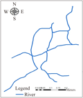
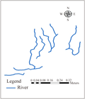
The drainage networks by large rectangular and trellis that are orienting the channels along North-East and East-West directions in the central domain. The drainage patterns are as follows (Figure 4-6, Table 2):
Ⅰ. Dendritic Pattern
Ⅱ. Trellis Pattern
Ⅲ. Rectangular pattern
Ⅳ. Sub-Parallel Pattern
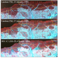
The course shifting and braided character of the alluvial river also gives some anastomosing pattern of channel. In the eastern side Ranaghat and Pasighat shows anastomosing pattern. In the eastern side of the river change its course occupying the other tributaries along with the main river (Talukdar, 2011; Ouchi, 1985). This type of anastomosing is found in intermittent to perennial stream systems with net long-term ero-sion, in contrast to braided streams which are characterized by net long-term deposition, and which occur within well-defined floodplains (Figure 7).
Acknowledgement
The authors are thankful to Assam University, Silchar and to the UGC, New Delhi for granting UGC-Fellowship to the First author.
References
Allan J.D. and Flecker A.S., 1993, Biodiversity Conservation in running waters. Bio-Science, 43: 32-43
http://dx.doi.org/10.2307/1312104
Armontrout N.B., 1990, Aquatic habitat inventory, Bureau of Land Management, Eugene District, USA, 32 pp.
Das B.K. and Kar D., 2011, Habitat Mapping, Spatial Analysis of Fish Diversity of River Subansiri during winter season in Assam and Arunachal Pradesh (India). Environment and Ecology, 29 (4A): 1948-1951
Das, B.K., Boruah, P. and Kar, D., 2014 a, Study of Seasonal Variation of Water Quality of River Siang in Arunachal Pradesh, India. IOSR Journal of Environmental Science, Toxicology and Food Technology (IOSR-JESTFT), 8 (2IV): 11-20
Das, B.K.; Boruah, P. and Kar. D., 2014 b, Potential Application of Geographic Information System (GIS) and Remote Sensing (RS) in River Analysis. International Journal of Recent Scientific Research,5 (4): 828-830
Das, B.K. and Kar, D., 2015, “Physico-chemical parameters and drainage types of River Siang in Arunachal Pradesh, India” in Mishra, G. C. (eds.) Conceptual Framework and Innovations in Agroecology and Food Sciences, Krishi Sanskriti Publications, New Delhi, India. pp. 53-56
Dudgeon, D., 2000, Conservation of Freshwater biodiversity in Oriental Asia: Constraints, Conflicts and Challenges to Science and Sustainability. Asia Oceania Report, 1: 237-243
http://dx.doi.org/10.1007/s102010070012
Jain, V. and Sinha, R., 2003, Hyperavulsive-anabranching Baghmati River system, north Bihar plains, eastern India. Zeitschriftfür Geomorphologie, 47 (1): 101-116.
Kar, D., 2007, Fundamentals of Limnology and Aquaculture Biotechnology. Daya Publishing House. New Delhi. India. pp. xvi + 609 p.
Kar, D., 2013, Wetlands and Lakes of the World. Springer, London. pp. xxx + 687
http://dx.doi.org/10.1007/978-81-322-1023-8
McConell, R.H., 1988, “Broad characteristics of the ichthyofauna,” in Bruton, M. N, and Sentongo, G. W. (eds.) Biology and ecology of African freshwater fishes, Orstom Publications, Paris. pp. 93-110
NBFGR, 2000, Manual on Habitat Inventory. National Bureau of Fish Genetic Resources (ICAR) (Lucknow), 27pp.
Nguyen, T.T.T. and De Silva, S.S., 2006, Freshwater Fin fish biodiversity and Conservation: An Asian perspective. Biodiversity and Conservation, 15: 3543-3568
http://dx.doi.org/10.1007/s10531-005-0312-8
Ouchi, S., 1985, Response of alluvial rivers to slow active tectonic movement. Geological Society of America Bulletin, 96: 504-515
http://dx.doi.org/10.1130/0016-7606(1985)96<504:ROARTS>2.0.CO;2
Pethiyagoda, R., 1994, Threats to the indigenous freshwater fishes of Sri Lanka and remarks on their conservation. Hydrobiologia, 285: 189-201
http://dx.doi.org/10.1007/BF00005666
Richter, B.D., Barun, D.P., Mendelson, M.A. and Master, L.L., 1997, Threats to imperiled freshwater fauna. Conservation Biology, 11: 1081-1093
http://dx.doi.org/10.1046/j.1523-1739.1997.96236.x
Roy, T.K., 1975, Drainage analysis in the upper Assam Valley. Indian Journal of Earth Sciences, 2: 39-50.
Saders, R. and Tabuchi, S., 2000, Decision Support System for Flood Risk Analysis for the River Thames, United Kingdom. J. Amer. Soc, 66: 4-10
Saha, K.K., Dave, H.D. and Mitra, D.D., 2006, Study of Tectonic Elements of Punjab Plains from satellite imagery, drainage network and gravity anomalies. 6th International Conference and Exposition on Petroleum Geophysics “Kolkata 2006”, 43-48
Schlosser, I.J., 1982, Fish community structure and function along two habitat gradients in a headwater stream. Ecol. Monogr, 52: 395-414
http://dx.doi.org/10.2307/2937352
Talukdar, R., 2011, Geo-morphological study of the Jia Bharali River catchment, N. E. India. pp. xii+275
Toham, A.K. and Tuegels, G.G., 1997, Patterns of Microhabitat use among fourteen abundant fish of the Lower
Ntem River basin (Cameroon). Aquat. Living Resour, 10: 289-298
http://dx.doi.org/10.1051/alr:1997032
Toham, A.K. and Tuegels, G.G., 1998, Diversity patterns of fish assemblages in the Lower Ntem River basin (Cameroon) with notes on potential effects of deforestation. Hydrobiologia, 141 (4): 421-446
. PDF(569KB)
. FPDF(win)
. HTML
. Online fPDF
Associated material
. Readers' comments
Other articles by authors
. Das B.K.
. Kar D.
Related articles
. Habitat Mapping
. Biodiversity
. Drainage
. GIS and Remote Sensing
. East Siang
. Arunachal Pradesh
Tools
. Email to a friend
. Post a comment

.png)

.png)
