The Influence of the Seaside Characteristics on the Tourist Ports and Their Impact on the Romanian Coast of the Black Sea 
 Author
  Correspondence author
International Journal of Marine Science, 2016, Vol. 6, No. 55 doi: 10.5376/ijms.2016.06.0055
Received: 17 Oct., 2016 Accepted: 28 Nov., 2016 Published: 19 Dec., 2016
Simon T et al., 2016, The Influence of the Seaside Characteristics on the Tourist Ports and Their Impact on the Romanian Coast of the Black Sea, International Journal of Marine Science, 6(55): 1-12 (doi:10.5376/ijms.2016.06.0055)
The Black Sea is an intra-continental sea situated between Europe (towards the west and north) and Asia (towards the east and the south). Its surface covers more than 450,000 km², occupying an important position among the intra-continental seas, which means that it’s almost two times larger than Romania.
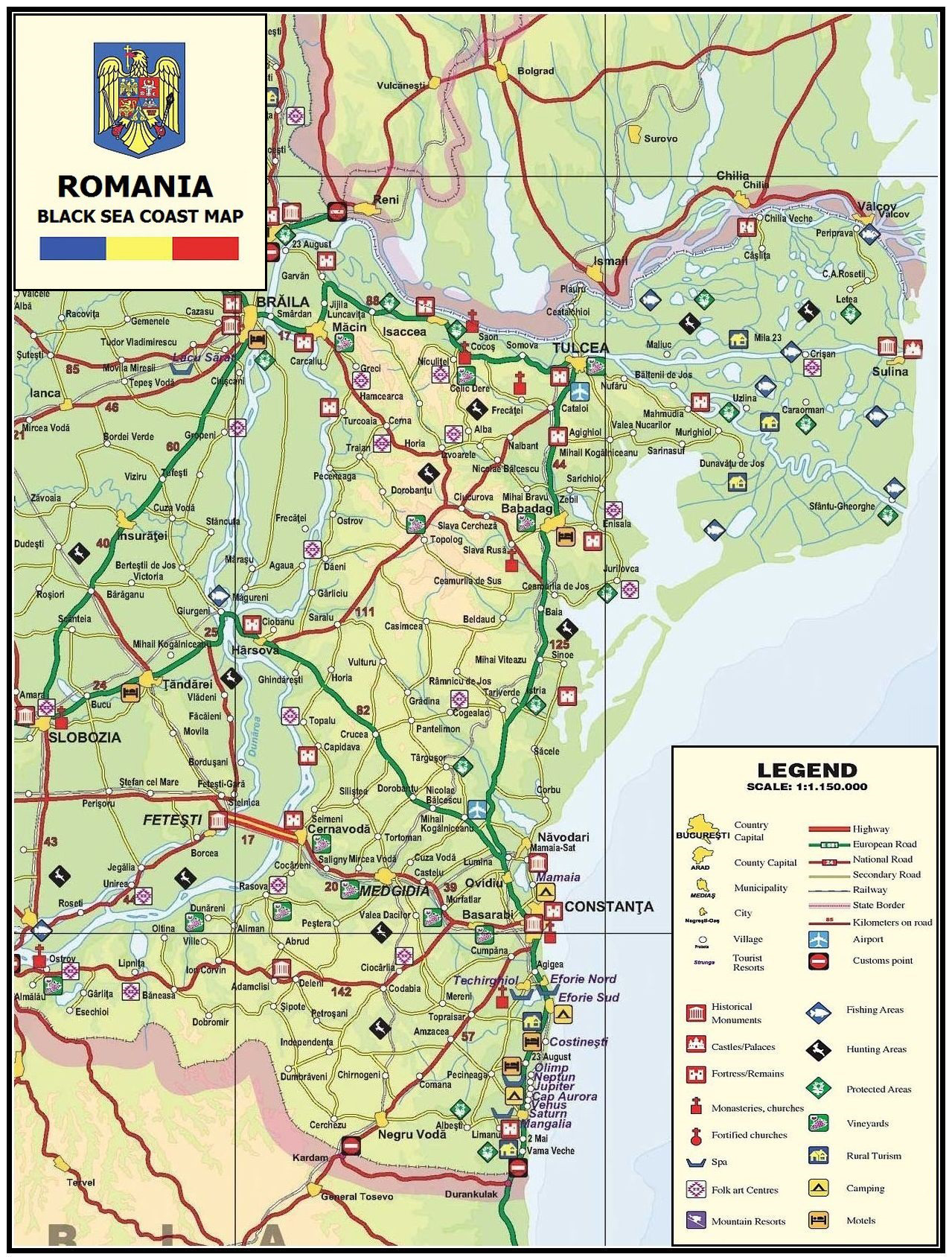
In our country the Black Sea boasts about 245 km of coast, of which 70 km include sand beaches, capitalised for tourism. While the seacoast belonging to the Danube Delta is protected as a Biosphere Reserve, the southern part of the seashore has been turned into a chain of resorts with 25 localities and 13 main resorts, all comprised in the Constanta county, visited annually by over a million tourists.
In order to enhance the attractiveness of the Romanian seashore after 1990, a new tendency appeared - to develop the nautical sports field. In this context, the authorities analysed the option of building tourist ports that had not existed during the period of the socialist economy.
Introduction
Through the government programme that finances scientific research, named NUCLEU, but also public initiatives, a Master-Plan was drawn up in 2012 and several studies and projects have been developed, for the creation of the first tourist ports in Romania, at the level of the public administrations in the Constantza county. Their creation depended seriously on the natural configuration of the coastline and the degree of economic capitalisation of the whole seaside area. The National Institute of Research-Development in Tourism has contributed to many of these, with studies supporting the development of recreational activities.
After the establishment of the socialist regime of 1947-1948 the investments in new facilities and tourist facilities continued uninterrupted. Large-scale coastal areas was launched in the years 1960-1970, characterized by building and equipping seaside resorts with large accomodation capacities, many equipped with the necessary tourism recreation, rest and treatment.
On the seacoast, the tourist industry in Romania has about 41%, representing 686 accommodation units and also the 145 ones of the Constantza municipality.
The new legal changes, economic after 1990 brought to the fore other requirements of diversification means of agreement. Since 1995, the seaside was questioned leisure development through sports.
Practicing these sports is through nautical a touristic ports.
The touristic ports offer basic tourist services and additional services (trade, catering, etc.). Practically, the ports are very diverse when it comes to size, organisation form, location of infrastructure and supra-structure and their performances.
Recreational nautical ports are classified in function of the services they offer, the compliance with certain building standards, aspect and also endowments. Thus, there are 4 categories of recreational ports: anchoring port, mooring port, marina with dry area storage and marina. Unlike the first three types of ports, the marinas can be classified in the following categories:
- category I: ports with high standards;
- category II: ports with medium standards;
- category III: ports with low standards.
Regardless of the physical characteristics of ports, managing these implies organising the port activities and services so as the port functions with the highest efficiency, based on its general development plan which must provide the best location for the port endowments, zoning of the territory, setting up the dimensions of the interior paths, of the closed storage spaces (warehouses) or free such spaces (platforms), taking into account also the future development possibilities and necessities.
In terms of theses marine equipment, Romania is trying to recover from behind and support the development of tourist ports function. In terms of these classifications cannot register than the average level of equipping.
1 Materials and methods
Research carried out was based, on the one hand a review of the actual degree of development of marine tourism. In this context, the institute held shares of topographic measurements to the configuration of existing shoreline and beach areas. From field data were obtained through local town halls on all existing tourism endowments.
Then they requested data on tourist ports already built. In addition, data were used and feasibility studies conducted by the institute from 2008-2012, for new tourist ports on the Black Sea. Also other studies were used on official certification of resorts, local or national interest, based on current legislation.
A coherent ensemble method was used, which were made connections between the data length, configuration, surface and structure of the Romanian coastline and its suitability for new investments in tourism. This is to try a reduction in the seasonality of tourism and diversified tourism activities cloudy days and less sunny.
In this context, it was selected area of interest has been identified problem that can lead to the development of tourist ports. Then bibliographic data was collected and the pitch. They identified characteristics Romanian seaside, which may provide new tourist ports. But the problem also included environmental impact, given that the Black Sea is semi -closed and can focus more pollution than other marine basins around the globe. In the final part, they were proposing a critical assessments and conclusions.
The entire analysis was based on the idea that it takes longer for a country which for 45 years has had an economy centralized, planned strictly socialist state. Changes the type of property and the laws do not bring very fast and his recovery lags the field of investments and tourism.
2 Discussions
2.1 The characteristics of the Romanian Black Sea coast
The Black Sea is a sea of continental type, semi-closed; it is part of the Atlantic basin, being situated between Europe and Asia, neighbouring Ukraine, Romania, Bulgaria, Turkey, Georgia and Russia. The Kerci Strait leads to the Azov Sea, the Bosfor Strait connects it with the Marmara Sea and the Dardanele Strait leads to the Egee Sea, thus to the Mediterranean Sea. It represents a remnant of the Sarmatic Sea and boasts several unique aspects in the world, (Vespremeanu E., 2005).
The relief includes three levels decreasing from the 0-meter level and has the following structure:
- The continental shelf, a first level located between depths of 0-200m, with aspect of slightly hilly submarine plain.The continental platform was involved, through its characteristics, to the creation of the Danube Delta;
- The continental slope (slope) is the second level, situated between -200m and -1500/-1800m. As structure, this is closer to the shore in its southern part.
- The abyssal plain is the last level of relief, between -1500/-1800m and -2211/-2245m, the maximal depth of the sea. This has a very smooth aspect, without large uneven parts.
The shore is a bit sinuous. In the northern part, Crimeea Peninsula closes the Azov Sea where it makes the connection with the Kerch Strait. There are few islands that are noticed: the Serpilor Island (Ukraine) and the Sacalin Island (Romania). There are a few bays: the Odessa Gulf and the Sinop Gulf are worth mentioning, due to their shape and size, (Vespremeanu E., 2005).
As for the climate, this is temperate-continental in the region, with seaside maritime sub-climate. The Romanian seashore competes with the Mediterranean one as it has a sunshine duration of about 10-12 hours daily, meaning about 2400 hours annually. The shore is oriented towards the east, with a maximum brightness during the day. The annual medium temperatures reach values around 24-25ᵒC in summer, sometimes with tropical temperatures exceeding 35ᵒC. The best months for tourism are July and August. The sea breezes, rich in aerosols, manage to diminish the heat of summer days.
The precipitations reach values between 350-600mm/year. The winters are cold but with few frosty days, often with strong winds. The wind regime is irregular. The dominant winds come from the north-north/east. These winds can sometimes reach 9-10 force on the Beaufort scale, especially during autumn and winter. In these cases, due to the strength of the winds, boats can find it difficult to stay in the natural harbours and they need special precautions.
As for the water, this maritime pool receives an important quantity of fresh water through a series of streams and rivers that flow towards the sea, fact which gives it a saltish character. Inside the Black Sea water pool, from the continental European side, the Danube, Nistru, Nipru and Bug rivers are flowing, with a contribution of 82%, followed by the rivers of the Crimeea peninsula with 0.14%, then those from Asia Minor with a contribution of 14% and the Caucasus ones with 4% (UNEP data,1989) and (Vespremeanu E., 2005).
Due to the considerable variability of the wind regime, the characteristics of the wave fields are modified significantly, cyclically in a year and have important inter-annual differences. The general north-south orientation of the shore-line and the‚ bathymetrical contours creates an important asymmetry in the distribution and propagation of waves in the shallow area through the refraction effect, which makes the waves become relatively parallel to the shore.
The waves have about 2-4m and during storms, they can reach 6-8m. The dominant winds are those from east (45%), NE (30%) and less from SE (19%) and rarely from north and south (6%). The highest peak of calm periods is in May (66.5%) and the lowest is in February (52.1%). The rate of periods with wind waves varies between 20.3% in May and 39.4% in October, while those with swell sea from 13.1% in June to 20.6% in November.
The tides are not significant as for their size or height in a year. This is due to the closed character of the sea. Their weak force was a factor in the creation and maintenance of the Danube Delta. The temperature of the surface waters is influenced a lot by the regime of the air temperatures; in the years with frost, an ice layer can appear on the NW seashore, including the Romanian one.
The temperature of deep waters stays constant at 9ºC (after passing through an intermediary surface of 5-7ºC). The structure of waters reveals two overlapping surfaces: the surface layer between 0-200m, oxygenated and biotic and the depth level, between -200/-2211m with sulphurous hydrogen and abiotic. This structure is maintained thanks to the lack of vertical currents that would blend the waters.
Salinity is also different, in function of the two water levels of the sea. The surface level has a low salinity of 15-16‰ and the depth level has a higher salinity, of 22-23‰. Having a reduced salinity, tourists can practice without problems sub-aquatic and nautical sports.
The main sea currents in the Romanian coast area are directed from north to south with a maximum speed of 0.5m/s and are caused by the rivers flowing into the Black Sea and the main winds. A characteristic of the higher circulation is the Rim current that encircles the Black Sea and forms a circle current at the level of the entire sea basin. The coast line and the extension of the Crimeea Peninsula create two circular currents that are weaker on the eastern and western parts; these are comprised by the Rim current.
The flora and fauna of the waters, due to the presence of the two different water levels, are not very rich in species. The coastal area owns few spaces with natural vegetation, especially in the Delta area and between the tourist resorts. In the water, there are different types of algae-red, blue, brown, found till about a 7-8m depth, where there is still light. The fauna includes species of fish such as sturgeons (Black Sea sturgeon, sterlet, beluga, etc.), gobies, herrings, small sharks, etc. The rare mammals living in the Black Sea are represented by three sub-species of dolphins: the harbour porpoise, the common dolphin, the ‘big dolphin’ (Tursiop struncatus) and a species of whale, specific to this marine area (Monachus monachus albiventer), the latter being in danger of extinction. There are no dangerous marine animals for tourists.
The protected areas related to the marine territory are a few and are concentrated especially in the Constanta county. The first protected area on the Romanian seashore is the marine reserve –“Acvatoriul Litoral Marin 2Mai-Vama Veche” (2 Mai-Vama Veche protected marine area), also declared a special conservation area inside the European Ecological Network Natura 2000-ROSCI0269. The area lying in the open sea is the restricted one. Only the ships of the area administrator, the Border Police and Military Marine in mission and those with salvation missions are excepted and are allowed to sail, stop and anchor in all the areas of the reserve.
The Natura 2000 has included the Black Sea bird-fauna protected area – with a total area of 147,242.9 ha of which about 50% (73,621.45 ha) assigned to the Constanta county; the same network has also comprised the following Sites of Community Importance:“Izvoarele sulfuroase submarine de la Mangalia”(the sulphurous submarine springs in Mangalia), “Plaja submersă Eforie Nord – Eforie Sud” (the North Eforie – South Eforie submerged beach) and “Zona marină de la Capul Tuzla”(the marine area in Tuzla Cape). ROSCI0094 site underwater sulphurous springs from Mangalia, contains the greatest diversity of marine habitats in Romania and has, overall, the welfare of conservation of all marine sites in Romania.
The sector delimitation of the Romanian seaside is based on the differences of the geographical and marine background. There are two well delimited areas, represented by:
- the northern area between the Musura Gulf and the Midia Cape, with a length of 165km that includes also a part of the Danube Delta, characterised by laguna zones, low beaches and soft submarine slopes;
- the southern area between the Midia Cape and Vama Veche, with a length of 82km, with a high degree of human intervention through the hydrotechnical constructions, cliffs, natural and tourism-designed beaches, dunes, sandbanks and salt lakes.
The last day of October has been designed as the International Day of the Black Sea, starting with 1996, when the environment ministers from the six bordering countries – Ukraine, Romania, Bulgaria, Turkey, Georgia and The Russian Federation signed the Action Strategic Plan for the Rehabilitation and Protection of the Black Sea.
2.2 The development of tourist ports on the Romanian Black Sea coast
The Romanian seashore is in general oriented to the north-south, with a length of 244km and a cliff height of about 25-30m in the area of the Constantza Port. The characteristics of the Romanian continental shelf allow an easy and safe navigation which doesn’t need to avoid navigation obstacles or islands and it doesn’t involve complicated itinerary changes or dangerous crossings.
Along centuries, the capitalisation of the shore area started quite late. The history of ports is connected to that of cities, Constantza and Mangalia in this case, with document attestations ever since the II nd century AD that were supported by other archaeological evidence from the VI th century BC. Two categories of ports were built:
- maritime ports : Constantza, Mangalia and Midia;
- river-sea ports: Sulina (at Mm 0-2), Tulcea (at km 70-72), Galatzi (at km 145.4-157) and Braila (at km 168.5-172);
The Romanian marine ports comprise housed pools, resulted from the building of piers and jetties which are in general created perpendiculary to the shore. Because of the stronger northern winds, the northern jetties of ports advance more to the deep sea and have stronger longitudinal profiles than the southern ones. These jetties deviate the seashore currents and sediment transport towards greater depths, fact which makes sediments be deposited further away from the seacoast, (Rowater/Masterplan, 2005).
The term‚ “marina” defines a port for small boats used for tourism, sport or recreation that has specific facilities. Starting projects for the development of tourist ports was an aspect that appeared after 1990, when the new political and juridical changes led to a higher interest for the leisure diversification and practice of nautical. The existence of commercial ports limited the emergence of tourist ports because of the contradictions connected to the traffic routes for the big and small boats and to the obligation to respect environment protection requirements. These are the main reasons for which the commercial ports have been presented.
More than that, the proposals for tourist ports determine the use of at least 200m of the existing beach for each port; this way, the beach capacity will decrease in the areas with accomodation units. The ports belong to the state and are administered by the municipal town halls as they need large areas and a high investment volume, with a relatively slow recuperation rhythm, extended over a longer period of time. There are also some private ports, usually small and that belong to some manufacturing companies. Even if ports are owned by the state (the berths and port facilities), in most of the cases, the recreational spaces supplementing the core activity-nautical tourism- belong to private firms.
.png) |
The Tomis tourist port offers a great potential for the capitalisation of nautical tourism, sport and recreational activities, representing a good shelter for the sport boats with sails.
The port was built in 1958 in the former Bay of Dolphins (Golful Delfinilor). The port space was created by closing this gulf space with two jetties: the northern, in a Y shape with an initial length of 400m, was extended in 2007 with one more segment of 200m; the eastern that continues with the cliff of the Casino of Constanza, with a 500m length. Three of its four sides (the eastern, southern and western ones) have been provided with mooring piers. The high degree of human intervention to the shoreline explain the biodiversity of flora and fauna reduced.
The depths are about 0.50m in the south-western part of the basin and 3m in the north-eastern area. Between 2008-2010, a series of investments were made that were theoretically meant to increase the annual traffic; the results were not those expected as some excavating and dredging works were needed. Concerning the Tomis port in Constantza, this was leased for 17 years to the “Sisteme Internaţionale de Afaceri”, private company (International Business Systems) by the Constantza Maritime Ports Administration National Company (CNAPMC).
The port shall organize the 1999 Rally yacht Kayra - rally with an itinerary of over 2000 nautical miles in 58 days and stops in 30 ports in six countries, which will include national Tomis port. Tomis Yacht Harbour Fair is organized every year in July, the only specialized trade fair for pleasure craft.
The Mangalia tourist port, also named the Mangalia Marina, is a tourist port situated in an area of constant tourist and commercial traffic. The port is 50 years old has an area of 200,000 msq. Mangalia port expansion was begun by cutting navigational channels and expanding Mangalia Lake dam breaks - wave from the north led to a retreat of shoreline, at a rate of 0.7 m/year.
For a quay length of 3.5km, the Mangalia marina is divided in 4 sections and a nautical zone. The last quay section, of -7.0m, allows the mooring of cruise ships of large capacity, with 450 seats. Saturn sector - Mangalia includes five protected beaches jettis eight sites and a dam break – wave. (Maximov et al., 2008).
The Mangalia Marina is the only tourist port on the Black Sea coast that has been designed with grant European funds (2012-2015), destined to recreational boats, being in line with European technical and quality standards, which will allow its inclusion in the highest standard networks of Black Sea and Mediterranean sea ports. At the same time, the Mangalia marina can be a basis for the coast tourist ships that sail along the Romanian coast, with stops in Neptun, Costineşti, Eforie, Constantza, Mamaia or Midia. Its capacity is 146 boats with a maximum length of 18m.
Thanks to its location, this port offers the perfect conditions for stationary boats, for the maintenance services for ships and even their use during winter on the Mangalia lake, during the times when the Black Sea is not available because of the weather conditions.
Here functions also the yachting school - "Black Sea Sailing School" where, during summer, every course week starts and ends on the same pier. The Mangalia municipality is a member of the Union of the Old Greek Ports in the Mediterranean and Black Sea basins since 1998 and this facilitates the inclusion of the Tourist Port in the field of such projects in Europe. The Tourist Port, together with the Varna Tourist Port from Bulgaria, is the host of the BMW Black Sea International Regatta, organised annually by the Romania Yacht Club.
.png) |
The Limanu Tourist Port is the largest private marina in Romania. It is located on the seashore, but has access to it through a channel over which passes the road that connects and 2 Mai Mangalia. Line beach is narrow and includes a cliff. Marina was taken over by the company Life Harbour, part of MedLife, 2012, at which time started its development, the piers, restaurant and hotel.
Life Harbour Mangalia Limanu is located in the estuary and has a surface gloss of water of 30,000 sqm and 670 m opening to the waterfront. Marina has 70 places for boats not exceeding 24m in length and 20 seats for small boats. Water depth is from 3 to 10m, providing a high safety for berthing maneuvers. Marina has 20 parking spaces guarded 24/24.Pune available many harbor services, from checking and repairing boats, antifouling, paint until the accommodation and catering.
Yearly, they organise here the yachting competitions – the Beneteau Regatta and the Insurers Regatta. With a surface of 30.000sqm and water depth of 3-10m, the Limanu marina allows the mooring of ships that do not exceed 24m, with 70 places and other extra 20 places destined for small boats.
The Eforie Nord (North Eforie) tourist port, named Belona, is located in the homonymous resort, in the bay outside the Europa hotel. This owns a surface of 2ha and can host lightweight recreational ships, cruise ships, sailing vessels and sport vessels. Type dam jetty in the southern port of Constantza to greatly reduced the intensity of wave action on the part of northern North Eforie sector by the diffraction of waves (Maximov G., 2008).
The Eforie Marina is well-known among navigators, tourists and even the region inhabitants as the Belona tourist port. The protected marine area can ccommodate in the piers’ area about 60 light ships. Inside the Eforie marina, ships arriving on water can enter through a buoy channel with a 12m width and a water depth of 3.5-4.2m. Marina has a capacity of 60 places for boats from 4 to 18m long and is occupied in summer by 90%. Marina Eforie work closely together with marine Limanu and organizes throughout the summer season, kingdoms: Eforie three and two Limanu, forming Romania Cup.
It exist and the recreational port, named Europa Yacht Club in Eforie Nord wasplanned and designed by the Ana Hotels private company, following an initial investment of 2 million euros, being the first private recreational port, built at European standards. This has received the “Blue Flag” international distinction (this programme awards the recreational beaches and ports for the quality of their natural environment).
But the narrow beach doesn’t offer the possibility of practicing very many sport activities on the beach or water surfaces. The Ana Yacht Club Marina is the first private recreational port in Romania. In 2014, it organised the Poseidon – Kaliakra Cup regatta which is registered in the sport calendar of the Yachting Romanian Federation, in the offshore segment.
.png) |
The Venus tourist is linked to the tourist resort of the same name. Venus to reach both by rail, the nearest station is in Mangalia where by car crossing the chain of seaside resorts on the European road E87 and Constantza-Mangalia Old –Vama and on to Bulgaria. Shore is fragmented into several coves and port are also in a southern golf resort. Near the port area beach sulphurous spring waters hypothermic captured and used as a spa. The coastline has fed artificial beaches and many protected by levees type jetty and break - wave, built in the late 70s.
This port includes only a floating pier, made of northern pine wood that allows the boat owners to freely moor for resting. These tourist ports have a major role in the diversification of seaside tourism. It is important to have not only hotels, bars and restaurants but also a tourist port, that, through its infrastructure to allow the mooring of ships, including yachts and motorboats. The maritime tourism in Romania can get gradually an international character, including these ports in a Black Sea tour.
In recent years, the authorities proposed the itinerary Istanbul- Varna- Constantza- Odessa- Yalta that could be done through a coastal navigation. But the new regional political and military regime diminished the chances for implementing this idea. The number of these tourist ports is insufficient if it is compared with the great number of nautical vessels in Romania. In conformity with the statistics provided by companies, in Romania there is a boat for 2,750 inhabitants, while in Italy, for example, the ratio is one ship for 66 inhabitants and in Poland – one for 471 inhabitants. The mean in the European Union countries is one for 76 inhabitants (2010).
The Sulina port is the only town of Sulina Delta’s Black Sea port function. Sulina is not directly linked to the road network in Romania and can be reached only by water, either the Danube or the Black Sea. The port has considered a proposal for creating and designing the Small Basin as tourist port (marina). But so far, no project got materialised in this regard. It would have been really useful for the development of leisure because the seaside area offers outstanding natural landscapes.
Many owners of yachts in Romania register their vessels in other countries (France, Cyprus, Turkey, Croatia, Greece) in order to avoid the paying of taxes. From 2009, the taxes for ships longer than 7m have been raised from 30% to 50% these being included in the category of luxury goods.
Even if there is development potential for the maritime recreation field, the lack of infrastructure, meaning some modern marinas where the yacht owners can keep their ships is the main factor that is stopping the yacht sale in Romania. Having in view this reason, the development of marinas and private ports will be one of the most successful investments in the following ten years.
For all nautical marinas role there are some general feature. From observations recorded over time it was found that extreme weather events that may occur near the Romanian coast of the Black Sea not significantly affect port activity.
Inside the port registers marine currents weaken, not influencing maneuvers and port activity. Besides the waves of the storm along this coast is manifested waves called Seisa. Seisakusho is a „stationary wave” and is typical for medium or dark basins such as the Black Sea. The phenomenon occurs every one to five years, between 1958 – 2005 registering five such events, which have caused flooding in the area of Sulina.
In the Black Sea region there is a risk of tsunami following the earthquake submarine. However, data on mathematical modeling of tsunamis in the Black Sea indicate that they are rare and do not represent a potential risk to coastal areas.
It recorded a net continuous average level of the Black Sea, since 1840 linked to rising global sea levels and oceans due to climate changes Increased relative level of the great contemporary period (in the last century) is between 2.8 to 3.1 mm per year, correlated with global growth Eustatie level seas and oceans of about 1.3 mm per year and subsidence of about 1.5 -1.8 mm per year (Panin N, 1999). How fitting quay is quality for all these ports, but needs upgrades to parking facilities and fuel supply, technical maintenance.
2.3 Proposals for new tourist ports – developing the Tuzla marina
The ports are surfaces delimited of the national territory, situated at the border of the seaside or of an interior waterway, naturally or artificially protected against waves, curents and ice, built and equipped asto allow the activities of maritime transport, receiving and hosting ships, as well as other activities.
The port covers all the protected marine areas, lands, hydrotechnical buildings, access channels, internal natural harbours, buildings, platforms, railways, roads, installations and equipments located in its perimeter. In Romania, the port activities are regulated by the Government Ordinance no. 22/1999. In conformity with the provisions of Decision no. 1136/18 September 2007, the maritime recreational port represents ‘the clearly defined area, designed for placing equipments and nautical recreational vessels and their launching to water’.
Increasing the attractiveness of some seaside areas, whose potential is not capitalised and the practice of nautical tourism at European standards would need a tourist port between the Eforie Nord and Mangalia resorts, as the distance of about 30km is too big for a safe navigation.
Thus, the authorities proposed (NIRDT, 2012) the creation of a marina in the Tuzla locality, with the aim of supporting the economic development, ensuring at the same time an optimal background for attracting internal and external investments and generating new jobs.
The Tuzla locality is located on the central eastern extremity of the Constantza county, on the border of the Black Sea, 25km. away from the Constantza municipality, with a population of 6228 persons, most of them Romanian and with Tatar, Rromani and Turkish minorities.(www.primaria-tuzla.ro). Tuzla has a narrow beach, wild and scenic, very sought after by those who appreciate tranquility.
The town boasts a narrow beach, wild and pittoresque, very much appreciated by those tourists seeking tranquillity. Tuzla has become a major attraction spot for the fans of thrilling sensations as the Tuzla aerodrome hosts parachute jumps and leisure flights. The Tuzla Lighthouse is the oldest one on the Black Sea coast, still operating in our days.
The tourist port will be built to the southern part of the Tuzla cape and lighthouse, in a large gulf, at the base of the high cliff. There is a road connecting the cliff and the port and this will be expanded and modernised in the near future. The partnership has been developed between the National Institute for Research-Development in Tourism, together with SC IPTANA S.A. and SC. IPROCHIM, all from Bucharest. (Herewith, photo of the Tuzla lighthouse).
Building the Tuzla tourist port is a broad objective involving several works, such as: housing jetties; inclined surface and shear for lifting and launching vessels; adjacent pier for the open sea jetty at -2.50m; jetty for limiting the mud fillings; mud fillings for the port area; booms scaffolds for the mooring of ships; storage platforms; fences; access road; buildings that will offer facilities for the marina (building, parking), an administrative building that will host these functional spaces: access hall, reception, toilets, offices, a travel agency, a currency exchange point, a fuel station cabin, utility networks, restaurants and bars, communications (post-office, telex, fax, internet), radio assistance (between the port and vessels).
By creating these facilities, the foundation of other branches is set, such as services, accomodation and catering units that will create new jobs and which will be really attractive for the potential Romanian or foreign investors.
.png) |
The emergence of the recreational vessels as well as the evolution of the locality as a tourist resort reveals the necessity of analysing the possibilities of creating a marina, adequate to this context. Locating the works has aimed both the functional aspects and especially those regarding the protection of the existing beach. Concerning the location, the authorities have taken into consideration these aspects:
- it shouldn’t affect the existent beach;
- there should be an adequate access route and to preserve the circulation along the beach;
- to organise the works in steps as to offer an adequate number of places for the vessel housing, corresponding to the demand;
- to offer a wide development perspective that should include the housing for ships in the cold season, repairing services and the option to moor small cruise ships;
- to offer a good housing for as long as possible all the year long;
- to offer facilities for the area where it is located.
For the intended location, the general features are presented: geographical setting, relief and climate. Thus, the land area of the Tuzla locality covers approx. 6,500m., bordered to the north by the Eforie Sud (South Eforie) resort and to the south by Costinești. The coast is sinuous and is bordered by high cliffs, specific of this seaside area, with a foundation of narrow beaches (excepting the Costineşti locality beach that is 800m long and about 10-50m. wide). The port enclosure will occupy about 70,000sq.m.from the shoreline to the sea. Of this area, the port platforms will cover about 23,000sq.m.and the protected sea area 43,667sq.m. The port capacity will be of minimum 50 vessels, with the possibility of future extension up to 200 boats.
The inclined surface for launching/lifting the boats will have a length of 50m.with a width of 6m. The jetties must provide a 3.0-3.5m.depth in the access channel. Depending on the number of vessels that will use the port and their dimensions, the mooring surfaces can be extended by the creation of triangle type piers, adjacent to the open sea jetty and southern jetty, where can be found depths of 3.0 - 3.5m, sufficient for the mooring of large vessels.
The marina will be a shelter, stopover and garage for the recreational ships and later, they will also build a workshop for repairs and maintenance of ships. The piers will be equipped with water and electricity outlets and in the southern jetty area, they will create a fuel station with buried metallic tank.
The land activities inside the port will take place on a surface of about 23,000sq.m. This will be achieved by filling the volume of about 45,000 cubic meters to the shore side of the harbour, till the 1.50m.depth of the sea. The port administration and the services will be grouped in an administrative pavilion, located in the centre of the plateau covering a 1ha.surface.
The authorities proposed 60 months as the project duration of the investment. The main stages for this project are specific to each activity, taking into consideration their particularities. Inside the study plan they have settled that:
- the annual port functional duration will be of 150 days;
- the number of mooring spaces: 50;
- the average number of daily uses: 3;
- average occupancy: 40%, with a rise of 3% per year;
- setting a mooring tax of 0.26 euros per ml/pier/day, with an annual 5% growth.
The conclusion is that a high degree of occupancy of the berth leads to the diminuation of the quality of the port services; on the other hand, a low occupancy rate (e.g. below 50% for the general cargo terminals) indicates an inefficient use of the available resources.
We can conclude that the degree of occupancy of the berth is an indicator that should be used carefully, as the tendency to extend this level over certain values can create port jams, while low values indicate an inefficient use of the resources. The studies of various cases and the port experience have proved that, for a general cargo terminal, a good occupancy level ranges between 60 ÷ 70%, while for specialised terminals (especially for those where arrivals can be planned thoroughly) occupancy can rise up to 80%.
This project was destined to receive funding under the Regional Operational Programme 2007-2014, taking into account the criteria imposed by the legislation in this period. The "Recreational marina in the Tuzla town" project could have been included in Prior Axis 5: Sustainable development and tourism promotion – Field of intervention 5.2. - Creating, developing, modernising tourism infrastructure for the capitalisation of natural resources and improving the quality of tourism services". The Constanta County Council endorsed favourably this direct investment project. Unfortunately, the Tuzla town-hall did not manage to attract the necessary European funding for this project, so agriculture still remains the dominant economic activity.
Conclusions
Geographical factors are essential in establishing and implementing the physical characteristics of tourist ports. The coastline dominated by the cliffs of the southern part, between Cape Midia and VamaVeche, was very influenced by anthropogenic intervention. For proper operation of tourist ports had kept distance to the commercial ports and shipyards, not impeding large ships. At present, Romanian tourist ports at fits the second category as the facilities and standards. Of the presented may present some conclusions:
1) The impact on marine biodiversity to touristic ports
The domestic component, navy and marine-salmastricola, the planktonic flora in this area represent about 66% of all species. Component alien, freshwater and freshwater salmastricola pierced through the contribution of continental waters, was poorly represented, constituting approx. 34%.
The issue of preservation of species of marine flora and fauna is given by the conditions made for pollution reduction. A positive aspect is the fact that nautical tourism marinas practiced in only three months a year, in summer. Therefore noise and water is reduced due to water self-cleaning capacity. More serious problems they bring great commercial vessels, freighters because there is not enough port facilities for taking solid and liquid waste products on board.
2) Marine erosion influence on the development of tourist ports
The rate of sea level rises is 2.2 mm per year and the erosion of values over 2m / year, a phenomenon observed especially after 1980. It is considered that this has contributed to the erosion of the beaches of the southern coast of the Black Sea. The sectors most affected by erosion are located in the south coast: Mamaia, Tomis, Eforie, Tuzla, Olimp, Venus, Saturn and Mangalia, 2 Mai - VamaVeche.
Rising sea levels, beach sediments could be pushed up and onto land, forming beaches steeper and narrower. This will influence the existence of tourist ports, dams mooring especially by increasing water depth and wave power, then coast doorways on the water, the pontoons difficult due to the increased slope of the shore line.
Where the beaches are lined inward structures to protect the coastline (Mamaia, Eforie, Venus), it is likely that increased exposure to beach erosion and waves higher on shoreline accelerate erosion on the basis of work and reduce the life of thereof.
3) Environmental impact of touristic ports
Marinas on Tarumi novelistic Black Sea can have an impact where shoreline and beach is strong anthropic with permanent structures and temporary by changes in water quality due to increased levels of turbidity and changes to sediment suspended and / or stored in these areas that could potentially have an adverse impact marine flora and fauna, especially the various species of molluscs (mussels, clams, snails), crabs and shrimp. Proposed structures have the potential to cause temporary displacement of fish and invertebrates during construction. The impact of tourism ports is below the surface since their deployment and reduced length of shoreline that is developed.
4) Future development of touristic ports in Romania
Recent was realized a project to create a touristic port Tuzla. This includes creating a platform modern port, and arranged an approach that combines the popularity of the area with all its advantages. Then pursued and improve infrastructure necessary for a modern port location and alignment of the new "product" - Port Travel Deals Tuzla among other already established (tourist ports in Turkey, Spain, Italy, Greece, Portugal). Deployment of such works was taken into account future development of Tuzla and Costinesti localities, the local economy and increase job growth. Direct contribution to increasing local budget and the central budget, through taxes and taxes on economic activities in the coastal zone.
Overall for all marinas, nautical industry revenues will come not only from the sale of boats but also related services. Thus their courses in order to obtain navigation certificates, renovation, maintenance and upgrading, mini cruises and boat rental, organizing teambuilding sea and then selling advertising space craft are additional sources of revenue for companies. Investments in marine ports certainly more profitable than real estate.
Ciortan R, 2009Port hydraulic structures, Agir publishing house, Bucharest, p. 1-409, Chapter V, cpI - pp.14-16, cp.V – pp.315-373;
Ciortan R., 2001,Port facilities improvement, Ovidius University Press, Constantza, cp.I/15.1. Maritime ports, pp.50-750;
Gâştescu P.,1996, Black Sea - basic geographical features, current status, monitoring and management concerns, Terra Magazine, vol. XXVI- XXVII, 1994-1995, ‘GlasulBucovinei‘ publishing house, pp. 22-31;
Maximov G. Stanica A., Dan S., Caravan Gh., 2008, The study of sedimentary processes on the southern Romanian Black Sea coast, Geo-Ecomarinarevew, no.14, Constantza, pp. 83-86.
Panin N., 1992, Impacts of expected climate changes and sea level rise on Romanian Black Sea shore, especially on the Danube Delta area. In: Implications of Climate Change in the Black Sea Region , Editor: Macram Gerges, UNEP (Oceans and Coastal Areas Programme Activity Centre) WG.19 / contribution 8,Istanbul, Turkey, p:1-11.
Vespremeanu E., 2005, The Geography of the Black Sea, Bucharest University Press Publishing, pp.9-178
Vodă Monica, OnicioiuIonica, Oncioiu Fl. (2015) Study on rehabilitation and tourism development and promotion of cultural Patrimony low growth pole Constantza, pp.94-96
***NIRDT, 2009, Study on development strategy of tourism in the south of the Romanian seaside resorts including for administrative and territorial units included in EforieCostineşti, Limanu, Mangalia, pp.2-112
*** NIRDT, 2011, Study to identify the tourist potential,flow and tourist destination in the CapulMidia-VamaVechesouthern sector coastline, pp.3-102
*** NIRDT, 2012, Planning the integrated development of nautical tourism in Romania, 3 phases, phase II-Spatial development of nautical ports,pp.35-135
*** NIRDT, 2012 Comparative analysis of competition for tourism forms and positioning the Romanian tourism offer versus the main competitors, phase II-Comparative analysis of international competition for coastal tourism, pp.5-92
*** NIRDT, 2007.Founding study for the certification/re-authorisation of Mamaia as a national interest resort, pp 5-27
*** NIRDT, 2008, Feasibility study for the creation of the Tomis and Tuzla marinas, pp.1-57
*** RW - Romanian Waters/ Water Basin Administration Dobrogea - Seaside et al., 2012, Master Plan"The coastal zone protection and rehabilitation”, pp.60-65
*** Guide of the seacoast and Danube Delta, bilingual, Publirom publishing house, Bucharest, pp.5-128
E-information sources:
https://ecomareaneagra.files.wordpress.com/2011/02/harta-litoralul-romanesc2.jpg
http://www.insse.ro/cms/files/publicatii/Breviar%20turism/Romanian_Tourism_2014.pdf, pp.28-30
www.mdrap.ro/userfiles/PATZ_zona_costiera_fazaIII.pdf
http://www.transport-research.info/sites/default/files/project/documents/eudet.pdf., pp. 2-230
http://www.rowater.ro/dadobrogea/MasterPlanprivindProteciaşiReabilitareaZonei/MasterPlan.pdf, pp.57
http://www.cjc.ro/Hotarari/2009/151-Local mayor's decision approving the feasibility study touristic port Tuzla, pdf
http://apmct.anpm.ro/documents/EA_Master-Plan_Port_Constantza_fin rapport_28.05.2015.pdf
http://www.mdrl.ro/_documente/turism/studii_strategii/masterplan_partea3.pdf, p.5-6
https://revistapontica.files.wordpress.com/2012/02/pontica-3-pag-87-98.pdf, pp.1-12
http://www.primaria-sulina.ro/primarie/pid/transportpid.pdf
http://www.azlsulina.3x.ro/id29.htm
http://www.portofconstantza.com/apmc/2016
https://izi.travel/it/6196-portul-turistic-tomis/ro
https://www.videoguide.ro/portul-turistic-mangalia.html
http://www.autentici.ro/locuri/portul-turistic-mangalia.html
http://www.travelinconstanta.ro/ro/event/portul-belona
http://www.zf.ro/analiza/piata-de-iahting-se-va-tripla-pana-in-2010-in-varianta-pesimista-3012602
http://www.trilulilu.ro/imagini-calatorii/farul-tuzla-imagini


. PDF(518KB)
. HTML
Associated material
. Readers' comments
Other articles by authors
. Tamara Simon
. Marioara Musteata-Pavel
Related articles
. Romanian sea shore
. Geo-physical characteristics
. Tourist ports
Tools
. Email to a friend
. Post a comment